In Indian agriculture, drone-based spraying has been hailed as a revolution. And in many ways it is — drones cover ground faster than manual labourers, reduce human exposure to chemicals, and can access terrain that conventional sprayers cannot. But there is a fundamental problem that the industry has largely ignored: most drone spraying today is just manual spraying with better delivery hardware.
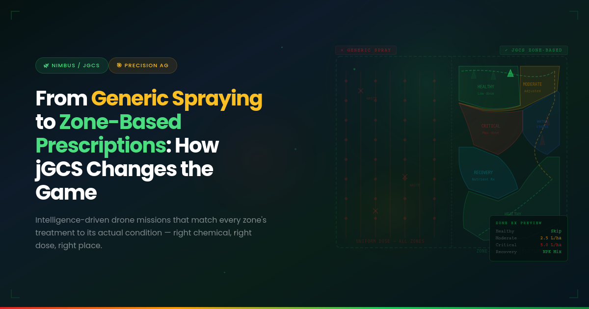
The same chemical formulation, the same flow rate, the same application pattern is applied uniformly across an entire field. A zone with heavy pest infestation receives the same treatment as a zone with no infestation at all. A patch of healthy cane gets the same chemical load as a patch showing early signs of disease. The drone may be precision hardware, but the intelligence driving it is anything but precise.
This is the gap that jGCS (Jarbits Ground Control Station) was built to close.
The Problem with Uniform Spray Protocols
To understand why jGCS matters, consider how drone spraying currently operates in sugarcane agriculture. A cane officer or mill agronomist identifies a general pest or disease concern for a field. A spray protocol is prescribed — typically a single chemical mix at a fixed concentration and flow rate. A drone operator is dispatched with instructions to spray the entire field using that protocol.
This approach has three critical flaws:
Over-Treatment of Healthy Zones
When every part of a field receives the same chemical application regardless of its actual condition, healthy zones are unnecessarily exposed to pesticides, herbicides, or fertilisers. This is not just wasteful — it actively degrades soil health over time, increases input costs for the farmer, and contributes to chemical runoff that contaminates water sources and damages surrounding ecosystems. In India’s sugarcane belt, where fields often border residential areas and water bodies, the environmental consequences of systematic over-spraying are significant.
Under-Treatment of Critical Zones
Conversely, a uniform protocol applied at moderate intensity may be completely inadequate for zones experiencing severe infestations. The chemical dosage that is “good enough” for an average field may be far too low to arrest an advanced pest outbreak in a localised hotspot. The infestation survives, spreads, and ultimately causes far greater damage than it would have if treated aggressively and early. What appears to be a cost-saving moderate application often becomes the most expensive choice when crop loss is factored in.
Zero Traceability and Accountability
With generic protocols, there is no systematic record of what was applied where, at what dosage, and with what result. The drone operator executes the mission and moves on. If the treatment fails, there is no data trail to diagnose why. Did the dosage fall short? Was the chemical inappropriate for the specific pest? Was coverage incomplete due to wind or flight path issues? Without zone-level traceability, every failed spray operation is a lost learning opportunity — and the same mistakes are repeated season after season.
| The Core Contradiction Drone spraying technology has advanced rapidly, but the intelligence driving it has not kept pace. The industry has precision delivery hardware operating on imprecise, one-size-fits-all protocols. jGCS resolves this contradiction by connecting AI-driven crop intelligence directly to drone mission execution. |
How jGCS Works: Intelligence-Driven Mission Planning
jGCS is not a standalone ground control station — it is the execution layer of the Nimbus ecosystem. It receives zone-based susceptibility maps and prescriptions from Nimbus’s AI engine and translates them directly into executable drone missions with minimal operator intervention.
The workflow operates through four integrated stages:
Stage 1: Susceptibility Mapping from Nimbus
Before any spray mission is planned, Nimbus analyses the field using multispectral satellite imagery and, where available, drone-captured data. Using Object-Based Image Analysis (OBIA), Nimbus segments the field into zones based on crop health indicators — not arbitrary grid cells, but meaningful agronomic units that reflect actual conditions on the ground.
Each zone is classified along a susceptibility gradient for biotic stresses (pest infestations, fungal diseases, bacterial infections) and abiotic stresses (water stress, nutrient deficiency, heat damage). The result is a high-resolution map where every zone has a specific risk profile.
Stage 2: Zone-Specific Prescription Generation
This is where the paradigm shift occurs. Instead of a single protocol for the entire field, Nimbus generates a zone-specific prescription for each identified segment. Each prescription specifies:
- Chemical Formulation: The appropriate pesticide, herbicide, or nutrient mix for the specific stress detected in that zone.
- Concentration and Dosage: The precise quantity adjusted to the severity of the condition. A zone with early-stage infestation receives a different dosage than one with advanced symptoms.
- Flow Rate: The litres-per-hectare application rate optimised for the crop canopy density and weather conditions in that zone.
- Application Timing: The recommended window for treatment, aligned with the crop’s growth stage and the pest’s lifecycle.
Stage 3: Automated Mission Planning
jGCS takes the zone-based prescriptions and automatically generates a complete drone mission plan. This includes:
- Optimised Flight Paths: The drone’s route is calculated to cover each zone in sequence, adjusting its flight parameters (altitude, speed, spray width) as it transitions between zones with different prescriptions.
- Dynamic Flow Rate Adjustment: As the drone moves from one zone to the next, jGCS automatically adjusts the spray nozzle flow rate and chemical mix to match the prescription for the new zone. There is no need for the operator to manually reconfigure mid-flight.
- Battery and Payload Optimisation: The mission plan accounts for battery life, tank capacity, and refill logistics, breaking complex multi-zone fields into efficient sortie sequences.
- Weather Integration: Wind speed, temperature, and humidity data are factored into flight planning to ensure optimal droplet deposition and minimise drift.
Stage 4: Execution, Monitoring, and Traceability
During execution, jGCS provides the drone operator with a simplified, guided interface. The operator does not need to understand the underlying agronomic logic or manually interpret the prescription map. jGCS handles the complexity, and the operator’s role is reduced to flight monitoring and safety oversight.
Every aspect of the mission is logged: flight path, spray coverage, chemical applied per zone, flow rates, timestamps, and environmental conditions. This creates a complete, auditable record of every intervention — enabling post-mission analysis of treatment effectiveness and continuous improvement of prescription models.
Generic vs Zone-Based: The Impact
| Dimension | Generic Spraying | Zone-Based (jGCS) |
| Protocol | Single chemical mix and flow rate for entire field | Zone-specific formulation, dosage, and flow rate |
| Intelligence Source | Manual assessment by cane officer | AI-driven susceptibility mapping from Nimbus |
| Operator Skill Required | High — operator must interpret instructions and manually adjust | Low — jGCS automates mission parameters; operator monitors flight |
| Chemical Usage | High — uniform application regardless of need | Optimised — applied only where needed, at the right concentration |
| Environmental Impact | Significant — over-spraying of healthy zones | Minimised — targeted application reduces chemical runoff |
| Treatment Effectiveness | Variable — under-treatment of hotspots common | High — dosage matched to severity |
| Traceability | None — no zone-level records | Complete — every zone logged with spray data and timestamps |
| Cost to Farmer | Higher input costs, lower ROI | Lower inputs, higher yield ROI |
De-Skilling the Last Mile
One of jGCS’s most underappreciated contributions is the de-skilling of field operations. In conventional drone spraying, operators need significant agronomic knowledge and field experience to execute effective spray missions. They must interpret complex instructions, manually adjust drone parameters mid-flight, and make real-time decisions about coverage and dosage. This creates a chronic talent bottleneck — there simply are not enough skilled agri-drone operators to serve India’s vast sugarcane belt.
jGCS inverts this equation. By embedding the agronomic intelligence into the software rather than requiring it from the operator, jGCS enables certified but less experienced operators to execute precision missions with the same effectiveness as a seasoned agronomist-pilot. The intelligence lives in the platform; the operator provides flight oversight.
Reducing the Carbon Footprint of Sugarcane Farming
Beyond yield and cost improvements, zone-based prescriptions contribute meaningfully to environmental sustainability. By applying chemicals only where needed and at the minimum effective dosage, jGCS reduces the total chemical load on agricultural land. This translates to lower chemical manufacturing demand, reduced packaging and transportation emissions, less groundwater contamination, and healthier soil microbiomes that support long-term productivity.
For sugar mills facing growing pressure from buyers and regulators to demonstrate sustainable sourcing practices, the traceability data generated by jGCS provides auditable evidence of responsible chemical management — a tangible asset in an industry increasingly shaped by ESG considerations.
Conclusion
The shift from generic spraying to zone-based prescriptions is not an incremental improvement — it is a fundamental rethinking of how drone technology should serve agriculture. Generic spraying treats the drone as a faster version of a manual sprayer. Zone-based prescriptions treat the drone as the execution arm of an intelligent system that understands the field at a level no human scout can match.
jGCS makes this transition operationally real. By automating mission planning, dynamically adjusting spray parameters across zones, de-skilling operator requirements, and generating complete traceability records, jGCS transforms drone spraying from a blunt instrument into a precision tool. Paired with Nimbus’s AI-powered crop intelligence and deployed through trained operators, jGCS represents the operational backbone of a new era in sugarcane agriculture — one where every spray decision is data-driven, every intervention is targeted, and every outcome is measured.
| About jGCS & Nimbus jGCS is the automated drone mission planning system within Jarbits’ Nimbus ecosystem for precision agriculture. jGCS translates AI-generated zone-based prescriptions into executable drone missions with minimal operator intervention. Jarbits is incubated at SIIC, IIT Kanpur and recognised among MeitY’s Top 30 AI Solutions. Learn more at jarbits.com. |