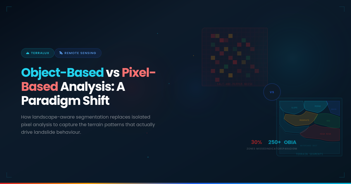
For decades, landslide susceptibility mapping has relied on pixel-based image analysis — a method that treats each individual pixel in a satellite image as an independent data point. While this approach provided a usable baseline, it suffers from fundamental limitations that have real-world consequences: 30% of high-risk zones remain unidentified, 19% of at-risk populations go unprotected, and roughly 15% of disaster mitigation budgets are misallocated due to blurred risk maps.
At Jarbits, our TerraLux platform takes a fundamentally different approach. By adopting Object-Based Image Analysis (OBIA), we analyse meaningful landscape segments rather than isolated pixels, capturing the spatial relationships and terrain patterns that actually drive landslide behaviour. This is not an incremental improvement — it is a paradigm shift.
The Problem with Pixel-Based Analysis
Traditional pixel-based methods assign a susceptibility value to each individual pixel based solely on the spectral or elevation values at that single point. Every pixel is treated independently, with no awareness of its neighbours, the shape of the terrain feature it belongs to, or the broader geomorphological context.
This creates three critical failure modes:
- Inaccurate Prediction: Without spatial context, pixel-based models struggle to distinguish between a steep but stable rock face and a similarly steep but critically unstable soil slope. The spectral signatures may look similar pixel-by-pixel, but the landslide risk is vastly different.
- False Alarms: Pixel-level noise — shadows, minor spectral variation, sensor artefacts — can trigger false positives. When every pixel is evaluated independently, there is no mechanism to filter out noise at the landscape scale.
False Sense of Safety: Conversely, a slope that appears stable at the pixel level may actually be part of a larger, degrading terrain unit. Pixel-based methods miss these emergent patterns, creating dangerous blind spots in risk maps.
The Invisible Battle
Current approaches leave disaster management authorities fighting blind. When 30% of high-risk zones go unidentified, the consequences are measured in lives lost and communities devastated — as the 2024 Wayanad disaster tragically demonstrated.
What is Object-Based Image Analysis (OBIA)?
Object-Based Image Analysis fundamentally changes the unit of analysis. Instead of treating individual pixels as independent observations, OBIA first segments the satellite imagery into meaningful spatial objects — contiguous regions that share similar spectral, textural, and geometric properties. These objects correspond to real-world landscape features: a hillslope, a drainage channel, a vegetation patch, a rock outcrop.
Once segmented, each object is characterised not just by its spectral values but by a rich set of properties including its shape, size, spatial relationships with neighbouring objects, texture patterns, and contextual position within the broader landscape. This mirrors how a geologist or terrain analyst actually reads a landscape — not pixel by pixel, but by recognising and interpreting terrain units.
How TerraLux Implements OBIA
TerraLux’s implementation of OBIA for landslide susceptibility mapping follows a rigorous, multi-stage workflow:
- Watershed-Based Segmentation: Rather than using arbitrary grid cells, TerraLux segments the landscape along natural hydrological boundaries. Using Digital Elevation Model (DEM) processing, we extract flow direction, calculate flow accumulation and drainage networks, and delineate catchment boundaries through pour point identification. These watershed units are the natural analytical units for mass movement processes because they directly encode terrain convergence, slope gradients, and drainage density — the factors that govern water flow and, consequently, slope stability.
- Multi-Source Data Fusion: Each watershed segment is enriched with over 250 geomorphological indicators computed from Sentinel-2 optical imagery, Sentinel-1 SAR data, digital elevation models, and rainfall datasets. These include slope, aspect, curvature, topographic wetness index, spectral vegetation indices, and structural geology features derived from multispectral and SAR imagery.
- Spatially-Aware Machine Learning: TerraLux trains its models using rigorous spatial cross-validation — ensuring geographic separation between training and validation sets. This prevents the data leakage problem that plagues conventional approaches, where models memorise location-specific patterns rather than learning transferable geomorphological relationships. The result is models that genuinely generalise across new terrain.
Pixel-Based vs Object-Based: A Direct Comparison
| Dimension | Pixel-Based | Object-Based (TerraLux) |
| Unit of Analysis | Individual pixel | Landscape segment / watershed |
| Spatial Context | None — pixels are independent | Full — shape, texture, adjacency |
| Boundary Definition | Fuzzy, salt-and-pepper noise | Clean, geomorphologically meaningful |
| Feature Richness | Spectral bands only | 250+ geomorphological indicators |
| Terrain Understanding | Point-level values | Landscape-scale patterns |
| Noise Sensitivity | High | Low — averaged within objects |
| Actionability | Pixel-level maps hard to interpret | Zone-level maps align with planning units |
Why This Matters for India
India’s landslide challenge is vast and growing. With 147 vulnerable districts across 13 states and over 50 million people exposed to recurring hazards, the stakes could not be higher. The 2024 Wayanad disaster — which claimed more than 200 lives and destroyed over 2,000 homes — was a painful reminder that the general vulnerability of regions like Wayanad was well known, but existing models lacked the spatial precision to provide actionable, location-specific warnings.
OBIA, as implemented in TerraLux, directly addresses this gap. By working with natural terrain units rather than artificial pixel grids, TerraLux produces susceptibility maps where:
- Risk zones align with actual geomorphological features that disaster managers can identify in the field.
- Boundaries between risk classes are crisp and interpretable, enabling precise resource allocation.
- The underlying drivers of risk (slope angle, soil saturation, vegetation loss, drainage patterns) are transparent and explainable through LIME and SHAP-based interpretability tools.
The Glass Box Approach
A critical advantage of TerraLux’s OBIA approach is that it supports what we call the “Glass Box” approach to AI. Unlike black-box models that output a risk score with no explanation, TerraLux provides explainable AI using LIME and SHAP. When the system flags a zone as high-risk, it also identifies the contributing factors — for example, a critical slope angle above 45°, soil saturation at 92%, and low vegetation cover. This transparency is essential for government decision-makers who need to justify evacuation orders, budget allocations, and infrastructure interventions.
Conclusion
The shift from pixel-based to object-based image analysis is not merely a technical upgrade — it represents a fundamentally different way of understanding terrain and predicting landslide risk. By analysing landscapes as interconnected systems of terrain units rather than collections of independent pixels, OBIA captures the spatial patterns and geomorphological processes that actually drive slope failure.
TerraLux brings this paradigm shift to operational reality, purpose-built for Indian terrain conditions and designed to reduce assessment costs by 60–70% while compressing timelines from 6–12 months to just 2 weeks. For State Disaster Management Authorities, researchers, and infrastructure planners, this is the difference between fighting an invisible battle and having a clear, actionable map of the threat landscape.
About TerraLux
TerraLux is Jarbits’ flagship geospatial AI platform for landslide susceptibility mapping and early warning systems. Recognised among MeitY’s Top 30 AI Solutions and incubated at SIIC, IIT Kanpur, TerraLux is India’s first agentic AI foundational model built for national-scale landslide risk assessment. Learn more at jarbits.com.