TerraLux selected among MeitY’s Top 30 AI Solutions addressing critical national challenges — a landmark validation for India-made geospatial intelligence.
A Moment of National Recognition
We are thrilled to announce that Jarbits Pvt Ltd has been selected as one of the winning teams of the IndiaAI Innovation Challenge 2024, organized by MeitY (Ministry of Electronics and Information Technology), Government of India. Our flagship geospatial AI platform, TerraLux, was recognized among the Top 30 solutions addressing critical challenges faced by India — a milestone that validates our mission to build world-class AI innovation from India, for India.
The IndiaAI Innovation Challenge received an overwhelming response from startups, researchers, and innovators across the country. After a rigorous multi-stage evaluation process spanning technical assessments, scalability reviews, and impact evaluations, TerraLux stood out for its innovation potential and real-world applicability in disaster risk reduction.
The Challenge We Set Out to Solve
India faces a severe and escalating landslide crisis. With 147 vulnerable districts across 13 states and over 50 million people exposed to recurring hazards — intensified by climate-change-driven monsoon variability — the need for intelligent, scalable early warning systems has never been more urgent.
The devastating 2024 Wayanad disaster, which claimed more than 400 lives and destroyed over 2,000 homes, laid bare a painful truth: the general vulnerability of regions like Wayanad was known, but the specific timing and location of slope failures were not. It was, in essence, a predictable tragedy with unpredictable timing.
Current landslide prediction models suffer from critical limitations. Approximately 30% fail to correctly identify high-risk zones. Nearly 19% of at-risk populations remain unprotected due to identification gaps. And around 15% of disaster mitigation budgets are misallocated because of blurred risk maps. Existing approaches are fragmented, slow to deploy, and prohibitively expensive.
TerraLux: Our Answer to the Challenge
TerraLux is an AI-powered geospatial intelligence platform purpose-built for landslide susceptibility mapping and early warning systems. It represents India’s first agentic AI foundational model designed for national-scale landslide risk assessment.
What Makes TerraLux Different
Physics-Informed Feature Engineering: Unlike conventional AI models that rely solely on spectral data, TerraLux incorporates physics-based modeling for terrain analysis. Using dynamic material modeling that accounts for the “rain factor” — how precipitation alters soil cohesion, friction angles, and unit weight — our system simulates the invisible pressures that precede slope failure. A proprietary analytical engine calculates Factor of Safety (FoS) values across thousands of slopes simultaneously, providing a clear, physics-based warning signal.
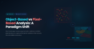
Object-Based Image Analysis (OBIA): Traditional pixel-based approaches struggle with spatial context and boundary definition. TerraLux’s OBIA framework analyzes meaningful landscape segments rather than individual pixels, capturing real-world terrain patterns through advanced watershed segmentation and delineation. This delivers superior performance in identifying susceptibility zones.
Spatially-Aware Cross-Validation: A critical flaw in many existing approaches is data leakage — where models inadvertently learn location-specific patterns rather than transferable geological insights. TerraLux implements rigorous spatial cross-validation with geographic separation between training and validation sets, ensuring that our models generalize reliably to new regions.
Spatio-Temporal Segmentation: Our framework captures seasonal terrain dynamics, from pre-monsoon degradation to monsoon-triggered failures, incorporating land use and land cover (LULC) change data spanning decades alongside real-time precipitation and SAR moisture proxy data.
Explainable AI — The Glass Box Approach: Government decision-makers need to understand why an AI system flags a risk, not just that it does. TerraLux uses LIME and SHAP-based explainability to identify the specific contributing factors — slope angle, soil saturation, vegetation cover — behind each risk alert, transforming black-box predictions into transparent, actionable intelligence.
An End-to-End Intelligence Pipeline
TerraLux automates the entire workflow from satellite data ingestion to risk map generation. The platform processes Sentinel-2 optical imagery, Sentinel-1 SAR data, digital elevation models, and rainfall datasets through a modular, JSON-driven pipeline orchestrator. It computes over 250 geomorphological indicators — including slope, aspect, curvature, topographic wetness index, and spectral vegetation indices — and trains machine learning models that produce classified risk maps (Very Low to Very High) with uncertainty quantification.
The result: assessment timelines reduced from 6–12 months to just 2 weeks, and costs slashed by 60–70% compared to traditional GIS consulting. A no-code, JSON-driven pipeline enables non-experts to deploy production-grade models with full scientific rigor.
India-First, Built for Scale
TerraLux is purpose-built for Indian terrain conditions — Himalayan geology, Western Ghats topography, and monsoon rainfall patterns. Our platform shall enable State Disaster Management Authorities to identify vulnerable zones, prioritize mitigation investments, and deploy targeted early warnings. The architecture is directly transferable to landslide-prone emerging regions across South Asia, Southeast Asia, and East Africa, which share similar geological conditions.
The Journey Behind the Achievement
This recognition is the culmination of years of work at the intersection of geospatial intelligence, AI/ML, and domain-specific engineering. As a bootstrapped deep-tech startup incubated at SIIC, IIT Kanpur under the Udaan Startup Acceleration Program, Jarbits has been building TerraLux with a singular focus: creating technology that protects lives.
Our team brings together expertise spanning aerospace engineering, AI/ML, geospatial science, and agronomy. Our mentors include leading geospatial intelligence researchers and senior technologists with successful startup exits. This blend of academic rigor and entrepreneurial execution is what makes TerraLux possible.
What Comes Next
With MeitY’s recognition comes responsibility. We are now working with the IndiaAI team on implementation milestones for deploying TerraLux at scale. The work order process is underway, and we are excited to move from prototype to production deployment.
This is just the beginning. We are committed to ensuring that India leads the world in leveraging AI for protecting vulnerable populations.
About Jarbits: Jarbits Pvt Ltd is a deep-tech startup building AI-powered platforms for geospatial intelligence, enterprise AI, and autonomous aerial platforms. Incubated at SIIC, IIT Kanpur | Recognized by MeitY, Government of India | LowCarbon.Earth 2026 Cohort | 5G/6G CoE, IIT Kanpur.
For partnerships and inquiries: contact@jarbits.com